Ground Penetrating Radar: What It Is And How Does It Work?
When you use a service locator to locate cables and pipes before starting a dig, you’ll notice that an Electromagnetic Field (EMF) locator is commonly part of the operation. An EMF locator can detect metallic service cables, but it’s not effective in detecting non-conductive services.
Because many services now use non-conductive materials like plastics and fiber optics, EMF locators may not be the best tool to use for some services. That’s when the use of Ground Penetrating Radar becomes a more efficient choice.
This post covers what a Ground Penetrating Radar is and how it works as an efficient tool for locating underground services.
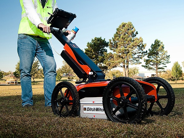
Ground penetrating radar being used to locate pipes on a sports field
What Is a Ground Penetrating Radar?
A Ground Penetrating Radar (GPR) is primarily a sensor device that has various applications including forensics. Now, it’s more often used for engineering applications like geophysical surveys.
In surveying engineering sites and structures, GPR uses a non-intrusive and non-destructive method of testing. It can scan through materials like concrete, asphalt and ground layers. It detects voids or cavities in the underlying structures to evaluate material integrity and quality.
It can also detect conductive (metal) and non-conductive (non-metal) materials in the subsurface. This is why service locators use GPR to detect and locate service or utility lines like cables and pipes that are buried underground.
How Does Ground Penetrating Radar Work?
GPR detects and locates materials in the subsurface by measuring the amplitudes of electromagnetic waves reflected from underground. These readings are used to produce an image of the condition and material composition beneath the tested area. It has four main components:
Transmitter
The GPR transmits or scatters pulses of high-frequency electromagnetic energy beams. These beams continue to transmit until a change in material composition is detected. Composition changes create a discontinuity in the transmission. A discontinuity made by solid materials will cause the transmission to bounce off and transmit back to the surface. A discontinuity made by a void or cavity will reflect a reverse polarity.
Receiver
When a transmission bounces or reflects back to the surface, the GPR’s receiver will pick up that transmission. The amplitudes of these bounced transmissions, together with their arrival times, are then recorded. These amplitude readings are then processed by the GPR.
Processor
After the GPR records the amplitudes of the bounced transmissions, the central processor will collate the readings. This will make out an image or graphic representation of the location and size of the detected materials.
Output
The imaging generated by the GPR’s processor is then shown on the display screen. The length and duration of the amplitudes reflect what type of material is detected. Together, these components allow the GPR device to collect and process data in real time. At SA Cable & Pipe Locating, Chris is able to upload this information onto a printed site map for you to use and keep.
What Is The Difference Between GPR And An EMF Locator?
Both GPR and EMF locator use electromagnetic energy, but in different ways. GPR measures the amplitudes of transmitted electromagnetic beams to detect materials underground. It doesn’t matter if the materials detected are metallic or not. As long as there is composition change, the GPR will pick up the variation and process them.
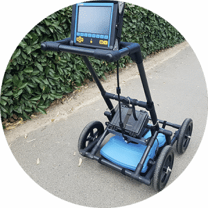
Ground Penetrating Radar
EMF locator, on the other hand, detects and traces electromagnetic transmissions through conductive (metallic) materials. Unlike GPR, the EMF locator depends on the presence of metal to detect transmissions. Without metallic conduction, no transmission can be detected.
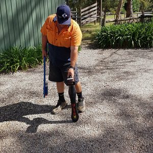
EMF locator being used to locate underground cables
This is the reason why most service locators still use GPR even after the site has been tested using an EMF locator. Though EMF locators are more affordable and can collect data faster, it may not be enough to perform a thorough survey of the tested site. This is crucial, especially when an extensive excavation or digging is going to be done on the site.
Where Can A GPR Be Used?
The GPR is commonly used to survey and investigate the ground for buried services. Ground surveys are mandatory prior to any excavation, construction or tunnel boring. By detecting and locating underground services, engineers can mark areas that workers should avoid or apply precautions. This is to prevent service line damage and service interruption, which can cost them a lot of money.
GPR can also be used on testing solid materials like concrete structures, masonry and asphalt paving. This type of testing evaluates the integrity and composition of the material or structure. It helps in determining whether a job has been done properly or if it needs to be redone.
GPR testing is also used to detect the location of cables and pipes embedded in concrete structures like walls, ceilings and flooring. This helps in locating damaged or faulty lines that need to be repaired or replaced. It prevents unnecessary breaking of concrete materials during inspection.

What Kind Of Materials Can GPR Detect And Locate?
Ground Penetrating Radar can detect a variety of metallic and non-metallic materials. The most common materials it’s used to detect include:
- Metal – metal pipes and cables
- Plastics – PVC pipes and fiber optic cables
- Concrete – concrete pipes and tunnels
- Masonry – stone slabs and tiles
- Subsurface voids – cavities or air pockets in the structure
- Geological composition – changes in the ground’s geological features and strata
GPR can also map and identify areas in the ground that have been excavated and back-filled. This helps in identifying ground disturbances that need to be reinforced or avoided.
How Deep Can A GPR Detect?
The penetration depth of GPR depends on the frequency settings and the intended application. GPR’s electromagnetic frequency can be set based on the type of testing that need to be done and the type of materials that need to be detected.
For example, in detecting pipes and evaluating ground structure thickness, the GPR’s antennae frequency is set to 900 MHz, which can penetrate as far as 0.9 metre. In surveying utility lines, the GPR’s frequency is set to 400 MHz to reach as far as 2 metres.
What Are The Limitations Of GPR?
Ground Penetrating Radar can penetrate and detect ground materials under fair conditions. However, there are circumstances that can cause interruptions and obstacles in the testing process.
GPR may not work efficiently under the following conditions:
- When used on waterlogged soil or clay soil
- There is presence of high mineral-containing sea water
- When used on solid metal structures
The reason for these is because the ions in the water minerals and dense metal can dissipate the transmitted signals. This will thus interrupt the transmitting and receiving process, which the GPR uses to evaluate the tested site.
What Are The Other Applications For GPR?
Aside from engineering applications, the GPR is also used in Earth Science, Archeology and Military fields.
The GPR is used in geological studies to evaluate and investigate changes in the conditions of the ground layers. GPR can image the structure of the bedrock, locate groundwater areas, and detect presence of ice.
In archeological geophysics, GPR is used to detect patterns in the subsurface. These patterns are used to map out buried archeological artifacts. GPR is an ideal tool for such test because it is non-intrusive and non-destructive. It thus prevents untoward damage to any valuable discovery.
In the military, GPR is used to evaluate the ground for buried ordnance (arms and explosives). It can also be used to detect underground tunnels that may be used in the secret transport and passage of military corpsmen and ordnance.
Who Can Use And Operate A GPR?
Ground Penetrating Radars are commonly used by accredited service locators in surveying a work site for utility and service lines. The GPR can only be operated by trained technicians who are capable of analysing and interpreting results.
The reason they use GPR is because it can map out the location of non-conductive service lines that may not be detected by EMF locators during the preliminary testing. Other advantages of the GPR include the following:
- Non-intrusive and non-destructive –
Service locators don’t need to dig up the ground to make a closer inspection of the site. - Fast collection of data –
Allows service locators to cover and scan large areas in a short period of time. - Requires single-sided access –
GPR only needs to scan from one side of the tested surface or site. It does not require the use of accessory devices on the opposite side of the tested area. - Cost-efficient and safe to use –
GPR can deliver results in real time so it saves more time and money on ground surveys. It is also one of the safest surveying methods because workers don’t need to dig around areas where there could be potential danger (example is the presence of leaky gas pipes).
Why You Should Use An Accredited Service Locator?
When you work on a site project, the first thing you must do is have the area surveyed for the presence of utility and service lines underground. This will help you ensure that you and your workers don’t dig into and damage any of those services.
If you are looking for an accredited service locator, in the Adelaide Hills, then SA Cable and Pipe Locating can make the ground surveying job easy for you. Tools like the EMF locator and Ground Penetrating Radar can survey the site in less time.
SA Cable and Pipe Locating can also perform Pipe Camera Inspections and Acoustic Water Pipe Locating to inspect and evaluate the integrity of pipelines that run throughout the site.
Other benefits of using an accredited service locator include the following:
- Industry certifications guarantee cost-efficient services that are of high quality.
- The use of quality high-performance tools brings fast and accurate results to save more time.
- Prompt service and professional advice help prevent unnecessary excavation, which can cost a lot of time, energy and money.
- Providing expense quotes prior to any job informs clients of the potential costs before making decisions.
If you prefer to survey your site using a Ground Penetrating Radar, make sure that you use only an accredited service locator. This will also ensure that the survey is done only by qualified and competent technicians.
Recent Comments